

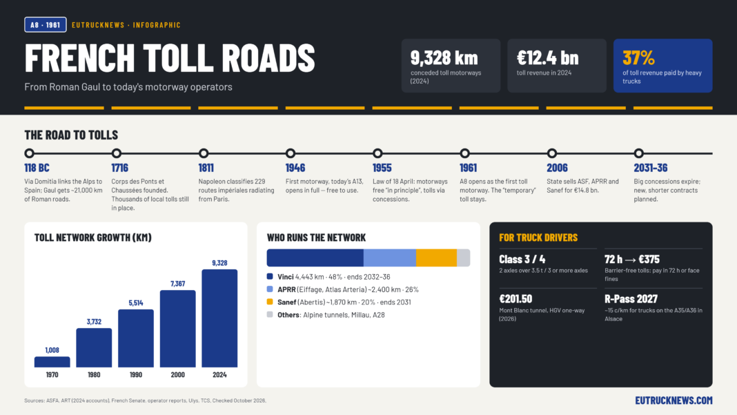

On 1 July 1961, France opened 63 km of the A8 between Puget-sur-Argens and Mandelieu-la-Napoule and asked drivers to pay. It was the first of France’s toll roads, and the toll was meant to last only until construction was paid off. It never went away (LCP). Today the conceded network covers about 9,300 km, and heavy goods vehicles pay 37% of a €12.4bn toll bill (ART). To see how France got there, start two thousand years earlier.
Rome lays the first grid
Rome gave Gaul its first planned network, roughly 21,000 km of roads by one estimate (Wikipedia). The Via Domitia, dated 118 BC, ran from Briançon over the Montgenèvre pass, crossed the Rhône at Beaucaire and continued through Nîmes and Narbonne to Spain. You can still see a paved stretch in Narbonne’s town square and the old Roman bridges at Ambrussum and Saint-Thibéry (Wikipedia). From Lugdunum (Lyon), Agrippa’s four roads fanned out to the Atlantic, the Channel, the Rhine and Marseille (Wikipedia). Agrippa’s Mediterranean branch roughly follows the line of the later Nationale 7 (Provence7).
Thousands of tolls and the forced-labour roads
After Rome fell, the roads broke up into local fiefdoms, each with its own toll. In the early 17th century France still had around 5,688 péages. In 1724 Louis XV set up a commission to deal with them, and over about fifty years it abolished 3,634 (Annales, 1962). Germany’s roads went through the same patchwork of tolls and escort fees, as our history of German roads shows.
At the same time, the state took road building in hand. The Corps des ponts et chaussées was founded in 1716. Its engineering school traces its origin to 1747, when Trudaine put Jean-Rodolphe Perronet in charge of training his royal mapmakers (École des Ponts). Peasants paid for the roads with their labour. From 1738 the corvée royale required between 8 and 40 days of unpaid road work a year (Larousse). Turgot abolished it in 1776, but it came back months later. The Revolution ended it for good in 1789–90. By then about 24,000 km of paved royal roads existed, although much of the 40,000 km planned in 1738 had never left the drawing board (Conchon, Cambridge).
Napoleon numbers the nation
A decree of 16 December 1811 classified 229 routes impériales into three classes. The 14 first-class roads radiated clockwise from Paris. The roads became routes royales in 1824 and routes nationales in 1830 (Wikipedia). The Paris–Nice road started as route impériale no. 8, was renumbered 7 in 1824, and took the RN7 name in 1870, according to enthusiasts at Provence7. The decree also reached the Low Countries, then part of the Empire, and laid the base of the network described in our history of Dutch roads. By 1845 the routes nationales covered 29,000 km (DREAL).
Then the railways took over long-distance travel. The rail network more than doubled, from 17,440 km in 1870 to 36,800 km in 1900 (DREAL). A tyre maker helped bring the road back. Michelin’s first guide appeared in 1900. In 1912 the administration refused to sign the roads, so Michelin put up its own signs, and its maps printed national roads in red (CFC).
The first autoroute was free
France’s first motorway, the Autoroute de l’Ouest (today’s A13 from Saint-Cloud), was declared of public utility in 1935. During the Occupation the Germans stored weapons in its tunnel. It opened in full on 9 June 1946, paid for by the state and free to use (Wikipedia).
That changed with the law of 18 April 1955, promoted by Antoine Pinay. The law said motorway use was “free in principle” but let concession companies charge tolls (LCP). It also created adossement: an existing concession could be extended to pay for new sections (Revue Politique). Semi-public companies were set up between 1956 and the early 1960s, and in a World Bank toolkit’s phrase, the exception quickly became the rule (PPIAF). The 1960 master plan provided for 2,000 km of conceded motorway and formally ended the “exceptional” status of tolls (Revue Politique).
From 1968, minister Albin Chalandon brought in private capital. Cofiroute, AREA, APEL and ACOBA were created between 1970 and 1973. After the 1973 oil shock the state took back the loss-making ones, and only Cofiroute stayed private (Chaire EPPP). The network grew fast anyway: 1,008 km in 1970, 3,732 km in 1980, 5,514 km in 1990, 7,367 km in 2000 and 9,328 km in 2024 (ASFA).
Privatisation and the “rent” debate
The companies were merged into three groups in 1994 (ASF, APRR and SANEF), and the state then sold its shares in stages. The last sale, in 2006, brought the state €14.8bn and took €16.8bn of debt off its books (Senate). Vinci bought ASF and Escota, an Eiffage-led consortium bought APRR and AREA, and Abertis bought Sanef (Public Sénat).
The deal has been criticised ever since. In 2014 the competition authority found net margins of 20–24% and compared them to a rent (Autorité de la concurrence). In 2020 the Senate calculated €24.3bn of dividends over 2006–2019 and judged the concessions about ten years too long (Senate).
Before and after: two road eras compared
| Free national roads era (1811–1950s) | Toll motorway era (1955–today) | |
|---|---|---|
| Legal basis | 1811 decree, routes impériales → nationales | 1955 law: free “in principle”, tolls via concession |
| Who pays | State budget (earlier, peasant labour via corvée) | Users; tolls are 97% of operator turnover |
| Flagship route | RN7 Paris–Menton (about 996 km, per enthusiasts) | A6/A7 Lille–Paris–Lyon–Marseille axis (1970–73) |
| Network | ~29,000 km of routes nationales (1845) | 9,328 km conceded (2024) |
| Operator | Ponts et Chaussées engineers | 20 concession companies, 21 contracts |
| Safety | Road deaths peaked at 16,545 in 1972 (6-day count) | 1.2 deaths per billion km on conceded motorways (2024, industry figure) |
Sources: Wikipedia, ART, ONISR, ASFA, Provence7.
Who runs France’s toll roads today
Three private groups share most of the map. Vinci is the largest, covering the south through ASF and Provence and the Côte d’Azur through Escota, the A8’s original operator. It also runs Cofiroute, the A19 south of Paris (Arcour) and Strasbourg’s A355 western bypass (Arcos) (Vinci). Sanef holds the north and east (A1, A2, A4, A16 and A26), and its subsidiary SAPN runs Normandy’s A13, A14 and A29 (Sanef). APRR, together with its subsidiary AREA and the new A79, makes up the third group, owned 52.5% by Eiffage and 30.8% by Atlas Arteria (Atlas Arteria). The Alpine tunnel companies ATMB (Mont Blanc, A40) and SFTRF (Fréjus, A43) were the state’s last direct motorway holdings. In 2026 the state sold its stakes in both to the Caisse des Dépôts for about €1.5bn, so both remain in public hands (CDC).
| Group (owner) | Main companies | km (approx.) | Concessions end |
|---|---|---|---|
| Vinci Autoroutes (Vinci) | ASF 2,730; Cofiroute 1,100; Escota 471; Arcour 101; Arcos 24; A86 Duplex 11 | 4,443 | 2032–2036 (historic); 2070–2086 (new) |
| APRR (Eiffage 52.5%, Atlas Arteria 30.8%) | APRR 1,908; AREA 409; A79 Aliae 88 | ~2,400 | Nov 2035; Sept 2036; 2068 |
| Sanef (Abertis) | Sanef 1,396; SAPN 372; A63 104; A65 A’liénor 150 (35%) | ~1,870 | 2031; 2033; 2051; 2066 |
| ATMB / SFTRF (Caisse des Dépôts since 2026) | Mont Blanc tunnel, A40, RN205; Fréjus tunnel, A43 | — | — |
| Others | CEVM Millau Viaduct (Eiffage); Alis A28 (124.6 km) | — | — |
Sources: Vinci URD, Atlas Arteria, Mundys, Alis.
Most of the network uses a closed system: you take a ticket on entry and pay by distance when you leave. Some sections are open, with a flat fee at a single barrier (Sénat). Tariffs change every 1 February, and the 2026 increase averaged 0.86% (Ulysse). The Millau Viaduct, opened in December 2004 with a pier 343 m tall, is France’s tallest bridge and was long the tallest in the world (Wikipedia).
Useful for drivers
- Vehicle classes. Class 3 covers 2-axle vehicles at least 3 m high or over 3.5 t. Class 4 covers 3 or more axles, and articulated or towing combinations at least 3 m high or whose towing vehicle is over 3.5 t (Vinci). Fleets use the interoperable TIS-PL badge (Ornikar).
- Free-flow tolling. The A79, A14 and A13 have no barriers, and the A40 Passy–Annemasse is due to follow in 2027. Without a badge you have 72 hours to pay. After that the fine climbs from +€10 to +€90 and finally a €375 fixed fine (Ulys).
- Alpine tunnels in 2026 (prices up 1.19%). Mont Blanc costs €201.50 one-way for HGVs (TCS). Fréjus (Italian-side prices, Euro 5–6) costs €204.80 for class 3 and €411.60 for class 4 (SicurAUTO).
- Alsace R-Pass from 1 January 2027. HGVs over 3.5 t pay about 15 c/km on average on the A35 and A36, roughly €24 for a north–south crossing in a heavy Euro 6 truck. Grand Est plans a similar charge (Trans.info).
- Concession end dates. The big concessions expire between 31 December 2031 and 30 September 2036, starting with Sanef. The government will keep the concession model with shorter contracts and profit caps, and says tolls will stay close to current levels (Assemblée nationale).
Rome built roads to move legions. Kings built them with forced labour, and Napoleon numbered them from Paris. The 1961 “temporary” toll is now France’s standard way of paying for motorways, and when the concessions end it will be renewed under new contracts, not removed.

